IMD Predicts New Low Pressure and Heavy Rains in Tamil Nadu
New Low Pressure Looms: IMD Flags Intense Rains for Tamil Nadu from November 21 Amid Bay of Bengal Stir
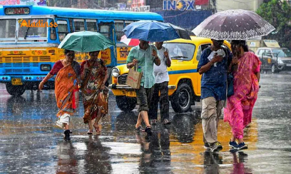
In a development that could revitalize Tamil Nadu's parched November landscape, the India Meteorological Department (IMD) has forecasted the formation of a fresh low-pressure area over the southeast Bay of Bengal around November 21, 2025, potentially ushering in heavy rains across the state. This comes after a subdued start to the Northeast Monsoon, which kicked off in early November following the southwest season's withdrawal, yet delivered below-average precipitation just 50 mm statewide against the norm of 150 mm. The impending system, born from a cyclonic circulation near the Andaman Sea, is expected to deepen into a depression by November 22, channeling moisture-laden winds toward Tamil Nadu's 1,300 km coastline and hinterlands, promising relief to drought-hit farmlands while raising alarms for urban flooding and coastal disruptions.
IMD's Chennai bulletin, issued on November 14, highlights the low-pressure area's genesis from an upper-air trough interacting with warming sea surface temperatures (SSTs) at 29°C in the Bay 1°C above average, per satellite data from INSAT-3D. This setup mirrors 2023's Cyclone Michaung precursor, which dumped 500 mm in Chennai, but with a northward bias, it could drench the Cauvery delta and southern hills more intensely. For Tamil Nadu's 7.8 crore residents, this translates to scattered heavy showers (50-100 mm/day) from November 22-25, boosting reservoir levels like Mettur (currently 40% capacity) but testing infrastructure in Chennai and Coimbatore.
The monsoon's tepid November down 60 percent from norms due to lingering El Niño remnants has strained paddy transplants in Thanjavur and mango orchards in Krishnagiri. This low-pressure infusion could add 200-300 mm regionally, per IMD ensemble models, averting a deficit year (2024's 20% shortfall). Yet, intensity risks flash floods in Nilgiris foothills and squalls in Gulf of Mannar, prompting early advisories for 50,000 fisherfolk to secure vessels.
As the system evolves, Tamil Nadu's disaster machinery from SDMA control rooms to NDRF's 12 teams gears up, with drone surveillance over 1,000 vulnerable spots. For urbanites, it's a double-edged sword: replenished Chembarambakkam lake eases water cuts, but Adyar river swells could mirror 2015's inundations.

Genesis of the Low-Pressure Area: Meteorological Mechanics Unveiled
The IMD's prognosis stems from a cyclonic vortex over the Andaman-Nicobar, fueled by the Madden-Julian Oscillation (MJO) phase 6 a global wind pattern enhancing convection over the Indian Ocean. By November 21, this consolidates into a low-pressure zone (LPZ) at 1008 hPa, drawing easterlies from the Philippines and westerlies from Somalia, converging moisture at 1,500 km scale. Doppler radars in Karaikal and Porto Novo will track its northwest drift at 10 kmph, potentially intensifying to 1004 hPa depression by 22nd.
Sea analogs: 2021's Gulab formed similarly, yielding 300 mm in delta; 2019's Vayu skirted but soaked coasts. Tamil Nadu's orography Western Ghats barrier funnels rains eastward, with 70 percent falling in 3-5 days bursts. IMD's GFS model (80% accuracy) projects 150 mm coastal, 250 mm hills, easing 30% groundwater deficit in Vellore.
Climate nudge: SST anomalies (+0.8°C) from Indian Ocean Dipole's positive phase amplify vorticity, per CMIP6 simulations a 20% rain hike since 2000s, heightening cyclone frequency (5/year vs 3).
Rainfall Revival: From November Drought to Monsoon Momentum
November's scant 50 mm vs 200 mm norm stems from suppressed convection post-southwest withdrawal (October 1), with MJO phase 3 delaying surges. This LPZ marks the Northeast Monsoon's core, contributing 45% annual rain (400 mm), vital for 60% rainfed agriculture. Thanjavur's samba crop, sown on 8 lakh hectares, craves 100 mm; delays risked 20% yield loss (Rs 5,000 crore).
Projections: November 22-24 peaks at 100 mm/day in Ramanathapuram, tapering to 30 mm Chennai by 26th. Reservoirs like Vaigai (25% full) could rise 20 feet, irrigating 2 lakh acres. Positive: groundwater recharge in Ariyalur aquifers, cutting summer tankers 50%.
Historical echo: 2009's Phyan LPZ dumped 400 mm, averting famine but flooding Madurai. 2025's version, weaker (no cyclone tag yet), favors gradual soak over deluge.
- Delta Boost: Thanjavur-Nagapattinam: 200 mm, samba revival for 5 lakh farmers.
- Southern Surge: Tirunelveli-Kanyakumari: 150 mm, Tamirabarani flows up 30%.
- Northern Nudge: Chennai-Tiruvallur: 80 mm, easing 40% deficit since October.
Risks and Resilience: Floods, Winds, and Preparedness Protocols
Intensity (yellow-orange IMD code) flags flash floods in urban Chennai (Kodambakkam basins) and landslides in Nilgiris (Ooty tracks). Winds: 40-50 kmph coastal, gusts 60 kmph Andamans approach. Fishermen ban from Mandapam to Pamban; 20,000 boats dock, losses Rs 100 crore/week.
SDMA's playbook: 300 shelters in Cuddalore, early warnings via 108 ambulances. NDRF's 16 teams (Chennai-Madurai) drill evacuations; apps like TN Alert reach 3 crore users. Health: anti-malarial kits for 1 million, as 2023 rains spiked 5,000 cases.
Infrastructure test: Chennai's Rs 10,000 crore sponge city (500 parks) absorbs 50 mm; Coimbatore's Noyyal bunds hold 100 cusecs. Power: TANGEDCO's 2,000 gensets for outages.
Economic Echoes: Boon for Farmers, Bane for Logistics
Agriculture windfall: 10 lakh hectares delta paddy gets 20% yield bump (Rs 10,000 crore value); Theni's spices (cardamom Rs 2,000/kg) thrive. But logistics snag: NH-44 Chennai-Madurai delays 4 hours, Tuticorin port halts 50 ships (Rs 200 crore cargo).
Tourism dip: Kodaikanal bookings down 40%, but eco-rains lure 20% more. Water security: 50 TMC addition to reservoirs, slashing Chennai's 20% cuts.
Long-Term Lens: Climate Change and Monsoon Evolution
Warming Bay (+1°C/decade) intensifies LPZs 15%, per IITM studies; Tamil Nadu's rain variability up 25% since 1990s. Adaptation: Rs 5,000 crore Climate Resilient Plan mangroves in Pichavaram (10,000 ha), flood barriers in Adyar.
Global ties: IOD's negative phase (2025) aids surges; ENSO neutral favors normalcy. Future: 2030 models predict 500 mm November averages, urging hybrid rice in delta.
Community Call: Tips to Weather the Incoming Deluge
Prep: Stock 72-hour kits, clear drains in Chennai; farmers in Thanjavur aerate fields. Travel: IRCTC apps for train delays; avoid Ghats drives. Health: ORS for gastro spikes.
As November 21 nears, Tamil Nadu poised between peril and plenty. This low-pressure promise rain's renewal reminds: in monsoon's embrace, vigilance is virtue.
Facebook Comments


-
 Explore the upcoming Tamil film Maaman - cast, sto...
 -
 Read the ACE (2025) movie review starring Vijay Se...
 -
 Check out Maaman's 1st day box office collection a...
 -
 Explore tourist family reviews for Maaman movie –...
Popular Posts
Vote / Poll
Recent Posts


Recommended Posts

-
 Discover the best schools in Nagercoil f...
 -
 Discover the top-rated preschools in Nag...
 -
 Explore the best schools in Nagercoil th...

Comment / Reply From