Bay of Bengal Low Pressure Sparks Heavy Rain Warnings Across Regions
October 24, 2025
Low Pressure Area in Bay of Bengal Sparks Heavy Rain Alerts
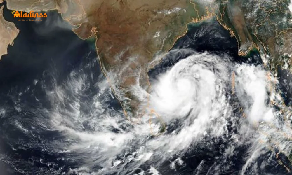
A low pressure area in the Bay of Bengal has formed, raising concerns about intensified weather conditions across parts of southern India. According to the India Meteorological Department (IMD), this weather system, which developed over the southeast Bay of Bengal and adjacent south Andaman Sea at 5:30 AM today, is expected to strengthen significantly by October 26, 2025. The system’s movement towards the west-northwest is likely to bring widespread rainfall, with some regions bracing for heavy downpours and gale-force winds. Tamil Nadu, Puducherry, and surrounding areas are already experiencing the effects of the intensifying northeast monsoon.
The IMD has forecasted moderate rainfall with thunder and lightning in Chennai and its suburbs today. Meanwhile, hilly areas like Coimbatore, the Nilgiris, and Erode are on alert for heavy rainfall. Districts such as Tirupattur, Vellore, and Ranipet are also expected to experience significant downpours. Fishermen have been advised to avoid venturing into the central-east Bay of Bengal due to anticipated gale-force winds reaching speeds of up to 65 kmph.
Weather System’s Path and Impact
The low pressure area, driven by atmospheric circulation, is projected to become more pronounced within the next 24 hours. The IMD indicates that the system’s westward movement could bring it closer to the Tamil Nadu and Andhra Pradesh coasts, potentially amplifying rainfall across these regions. The northeast monsoon, which typically brings heavy rains to southern India, is gaining strength, and this weather system is expected to exacerbate conditions.
The southeast Bay of Bengal, where the system originated, is a hotspot for cyclonic activity during this season. The IMD’s warning about gale-force winds underscores the need for caution, particularly for coastal communities and maritime activities. Fishermen have been urged to stay ashore, as rough seas could pose significant risks. The combination of heavy rainfall and strong winds may also lead to disruptions in transportation and daily activities in affected areas.
Regional Rainfall Forecast
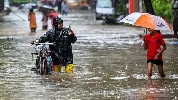
The IMD has issued specific forecasts for various regions. Tamil Nadu and Puducherry are expected to see widespread rainfall today, with some areas experiencing intense showers. In hilly regions, such as Coimbatore, the Nilgiris, and Erode, heavy rainfall could lead to flash floods or landslides, prompting local authorities to remain vigilant. Similarly, Tirupattur, Vellore, and Ranipet are under a heavy rainfall warning, with residents advised to take precautions.
Chennai, a major metropolitan hub, is likely to experience moderate rain with thunder and lightning. While this may not cause significant disruptions, the IMD has advised residents to stay updated on weather alerts. The city’s suburbs, including areas like Tambaram and Kancheepuram, may also see similar conditions. The forecast highlights the need for preparedness, as the weather system could intensify further as it moves closer to the coast.
Safety Measures and Precautions
With the low pressure area strengthening, authorities are taking proactive measures to ensure public safety. The IMD has advised against fishing in the central-east Bay of Bengal, where winds could reach dangerous speeds. Coastal communities have been warned to secure boats and fishing equipment to prevent losses. Local governments in Tamil Nadu and Puducherry are also preparing for potential flooding, with emergency response teams on standby.
Residents in low-lying areas are being urged to stay alert for possible flooding, particularly in regions prone to waterlogging. The hilly districts, where heavy rainfall is expected, are at risk of landslides, and authorities have advised against unnecessary travel. Schools and businesses in affected areas may face closures or adjusted schedules depending on the severity of the weather.
What to Expect in the Coming Days
As the low pressure area moves west-northwest, its impact will likely extend beyond Tamil Nadu and Puducherry. Neighboring states like Andhra Pradesh and Karnataka may also experience increased rainfall as the system progresses. The IMD is closely monitoring the situation and will provide updates as the weather system evolves. If the low pressure area strengthens further, it could potentially develop into a depression or even a cyclonic storm, though this remains uncertain at this stage.
For now, residents are advised to stay informed through official IMD updates and local news channels. Preparing emergency kits, securing homes, and avoiding unnecessary travel are key steps to ensure safety. The northeast monsoon is known for its unpredictability, and this weather system underscores the importance of preparedness in the face of changing conditions.
How to Stay Safe During Heavy Rainfall
To mitigate the risks associated with heavy rainfall and strong winds, residents can take several practical steps:
- Monitor weather updates from reliable sources like the IMD.
- Avoid travel during heavy rainfall, especially in hilly or flood-prone areas.
- Secure outdoor items to prevent damage from strong winds.
- Prepare an emergency kit with essentials like food, water, and first-aid supplies.
- Stay away from waterlogged areas to avoid accidents.
The low pressure area in the Bay of Bengal is a reminder of the region’s vulnerability to extreme weather during the monsoon season. By staying informed and prepared, residents can minimize risks and stay safe.
Comment / Reply From
No comments yet. Be the first to comment!