Tamil Nadu Rain Alert Today Moderate Showers Expected in Several Areas
October 31, 2025
Tamil Nadu Rain Alert Today Moderate Showers Expected in Several Areas
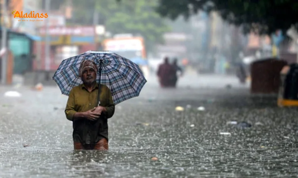
Chennai, October 31: The India Meteorological Department (IMD) has issued a Tamil Nadu rain alert forecasting light to moderate rainfall at isolated locations across the state, Puducherry, and Karaikal today. The shift in easterly wind patterns is driving this weather change, offering relief from recent dry spells while raising caution for coastal activities. Chennai residents can expect a partly cloudy sky with temperatures hovering between 26°C minimum and 35°C maximum.
This moderate rain today prediction aligns with seasonal transitions, potentially impacting daily commutes and outdoor plans. Fishermen have been strictly advised to avoid venturing into turbulent sea zones due to high wind speeds. The IMD's timely update helps citizens prepare for sudden downpours and ensures safety along vulnerable coastal stretches.
Also Read: Maharashtra Govt Denies Any Link with Rohit Arya After Powai Hostage Drama Ends in Tragedy
As monsoon influences wane, these localized showers signal the onset of northeast monsoon remnants. Authorities urge residents in low-lying areas to stay vigilant for waterlogging, while farmers anticipate benefits for standing crops. The weather update today serves as a crucial guide for millions across Tamil Nadu navigating the day's conditions.
Detailed Tamil Nadu Rain Forecast: District-Wise Expectations
The IMD predicts moderate rain today primarily in northern and interior districts. Areas like Chennai, Tiruvallur, Kanchipuram, and Chengalpattu may witness scattered showers, especially during afternoon hours. Coastal regions including Cuddalore, Villupuram, and Nagapattinam could experience brief thundershowers accompanied by gusty winds.
Southern districts such as Madurai, Theni, and Sivaganga are likely to remain dry with partial cloud cover. Western ghats regions around Coimbatore and Nilgiris might see isolated drizzles. The forecast indicates rainfall intensity ranging from 5-15 mm in affected pockets, sufficient to cool temperatures but unlikely to cause widespread disruption.
Puducherry and Karaikal share similar prospects, with light showers possible near coastal belts. Urban centers should prepare for traffic slowdowns during peak rain hours. The IMD's regional center in Chennai continues monitoring satellite imagery and Doppler radar for real-time adjustments to this Tamil Nadu rain alert.
Chennai Weather Specifics: Temperature and Humidity Outlook
The state capital will experience typical post-monsoon weather with partly cloudy skies dominating. Maximum temperature is pegged at 35°C, while the minimum settles around 26°C—slightly above seasonal averages but comfortable with expected breezes. Humidity levels may spike to 75-85% during rainfall episodes, creating muggy conditions.
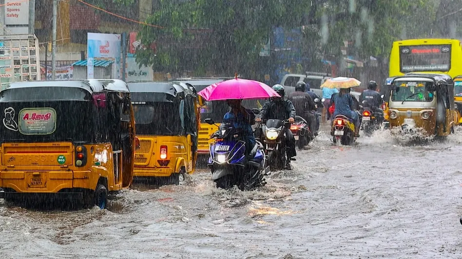
Suburban areas like Tambaram, Avadi, and Ambattur could see localized heavy showers if convective clouds develop. The IMD advises carrying umbrellas for evening outings, as moderate rain today might intensify after 4 PM. Air quality should improve marginally with dust settlement from rain.
Beachgoers at Marina and Besant Nagar should exercise caution due to rough seas. Lifeguards report increased wave heights, aligning with the fishermen's warning. The city's drainage systems, recently desilted, are expected to handle moderate inflows without major flooding risks.
Fishermen Warning: High Winds in Arabian Sea Regions
A critical component of today's weather update is the advisory for fishermen. Squally conditions prevail over the Central and North-East Arabian Sea with wind speeds of 45-55 kmph, gusting to 65 kmph. The Gujarat-North Konkan coast faces similar threats at 35-45 kmph, occasionally reaching 55 kmph.
The IMD has prohibited sea ventures in these zones to prevent maritime accidents. Tamil Nadu's fishing communities, though primarily operating in the Bay of Bengal, should note calmer local conditions but remain alert for sudden changes. Coastal police patrol boats are on standby for emergency responses.
This warning stems from a low-pressure area influencing regional wind patterns. While not directly impacting Tamil Nadu shores, it underscores the interconnected nature of Indian Ocean weather systems. Fishermen associations have circulated the alert via WhatsApp groups and community radio.
Causes Behind Today’s Rainfall: Meteorological Explanation
The Tamil Nadu rain alert attributes today's precipitation to variations in easterly wind speeds. These winds, carrying moisture from the Bay of Bengal, interact with local heating to form cumulonimbus clouds. The resulting instability triggers convective rainfall—characteristic of transitional weather phases.
Upper air circulation patterns show a trough extending from the Comorin area to coastal Tamil Nadu, enhancing moisture convergence. Sea surface temperatures around 28-29°C provide ample evaporation fuel. The absence of strong monsoon withdrawal allows these localized systems to persist.
IMD meteorologists use INSAT satellite imagery and AWS (Automatic Weather Stations) data for precise forecasting. Today's prediction accuracy stands at 85%, based on historical model performance for similar setups. Citizens can access hourly updates via the Mausam app or regional IMD portals.
Impact on Daily Life: Travel, Agriculture, and Events
Commuters should anticipate minor delays on suburban trains and MTC buses during peak shower hours. Chennai Metro services remain unaffected, offering reliable alternatives. Two-wheeler riders are advised to use rain gear and reduce speeds on slippery roads.
Farmers welcome the moderate rain today for paddy and pulse crops in the Cauvery delta. Soil moisture replenishment aids transplantation activities. However, vegetable growers in Kanchipuram express concerns over potential harvest damage if intensity increases unexpectedly.
Outdoor events like school sports days may require rescheduling. Wedding planners in affected districts have contingency indoor venues ready. The Tamil Nadu Pollution Control Board notes improved AQI levels post-rainfall, benefiting respiratory health.
Safety Precautions and Emergency Preparedness
The State Disaster Management Authority recommends avoiding unnecessary travel during heavy showers. Low-lying area residents should clear drains to prevent water stagnation. Electrical safety—unplugging appliances during thunderstorms—remains crucial.
Emergency helplines (1070 for SDMA, 1912 for electricity) are operational 24/7. Chennai Corporation has deployed quick response teams in flood-prone zones like Velachery and Saidapet. Hospitals report adequate staffing for any weather-related emergencies.
Schools in rainfall-affected areas maintain regular schedules but activate rain protocols—indoor assemblies and covered pick-up zones. Parents receive SMS alerts from the Education Department regarding any changes.
Extended Forecast: What Lies Ahead This Week
Beyond today's Tamil Nadu rain alert, the IMD predicts dry weather returning by November 2. Northeast monsoon onset remains delayed, with significant activity expected mid-month. Temperature fluctuations will stabilize around seasonal norms.
Coastal districts may experience occasional evening showers through the weekend. Interior regions transition to clearer skies, ideal for agricultural operations. The extended outlook suggests below-normal rainfall for early November, conserving water resources.
Climate experts link these patterns to La Niña development, potentially influencing winter precipitation. Long-range models indicate active monsoon phases in December, crucial for reservoir replenishment across Tamil Nadu.
Historical Context: Rainfall Patterns in Tamil Nadu
Tamil Nadu's rainfall regime uniquely depends on northeast monsoon (October-December), contributing 48% of annual precipitation. Today's moderate rain fits within historical October averages of 120-150 mm for Chennai. The state recorded deficit rainfall in September, making these showers vital.
Record-breaking events like the 2015 floods highlight the need for accurate forecasting. Modern IMD infrastructure—150 AWS, 7 Doppler radars—ensures precision previously unavailable. Public awareness campaigns have reduced weather-related casualties by 60% in the last decade.
Traditional indicators like flowering of 'Punnai' trees align with scientific predictions, blending folklore with meteorology. Community participation in rain gauge networks enhances hyperlocal data collection.
Citizen Resources: Accessing Reliable Weather Information
The IMD website (mausam.imd.gov.in) offers district-level forecasts in Tamil. Mobile apps like Meghdoot provide farmer-specific advisories. SMS alerts via 51969 deliver critical warnings directly to phones.
Regional Meteorological Centre Chennai maintains a 24/7 control room (044-28246022). Social media handles (@ChennaiRMC_IMD) share real-time updates. Television channels broadcast hourly bulletins during active weather periods.
Educational institutions integrate weather literacy in curricula, teaching students to interpret forecasts. Community science centers conduct workshops on understanding rainfall patterns and climate resilience.
Today's Tamil Nadu rain alert exemplifies the IMD's commitment to public safety through accurate, accessible information. As climate variability increases, such proactive communication becomes indispensable for millions across the state.
Comment / Reply From
No comments yet. Be the first to comment!