Northeast Monsoon Starts Tomorrow in Tamil Nadu: 17 Districts Alert
October 15, 2025

Northeast Monsoon Onset in Tamil Nadu Tomorrow: Heavy Rainfall Alert for 17 Districts
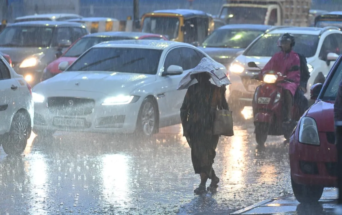
Tamil Nadu is bracing for the arrival of the northeast monsoon starting tomorrow, October 16, 2025, as announced by the Regional Meteorological Centre in Chennai. This seasonal shift promises above-average rainfall, with forecasts indicating heavy downpours accompanied by thunder and lightning across the state today and intensified precipitation in 17 districts over the coming days. Unlike the southwest monsoon, which primarily benefits northern India, the northeast monsoon delivers the bulk of Tamil Nadu's annual rainfall-typically around 44 cm from October to December-making it crucial for agriculture, water reservoirs, and urban infrastructure.
The onset coincides with the withdrawal of the southwest monsoon from the country, expected to conclude today. Early indications show promising precipitation, with 8 cm recorded in Tamil Nadu from October 1 to 14-2 cm above the norm-setting a positive tone for reservoirs like Mettur and Vaigai. Meteorologists predict over 50 cm for the season, potentially alleviating drought concerns in southern districts while raising flood risks in low-lying areas.
Coastal winds in the Comorin Sea region may gust up to 55 km/h until October 18, prompting advisories for fishermen to avoid venturing out. This northeast monsoon Tamil Nadu forecast emphasizes preparedness, with authorities urging residents to monitor updates from the India Meteorological Department (IMD).
Understanding the Northeast Monsoon: Tamil Nadu's Lifeline
The northeast monsoon, also known as the winter monsoon, originates from low-pressure systems over the Bay of Bengal, drawing moisture-laden winds from the eastern Indian Ocean. For Tamil Nadu, it accounts for nearly 48% of annual rainfall, far surpassing the southwest monsoon's 32% contribution. This reversal-where retreating southwest winds pick up moisture over the sea-brings relief to the state's rain-shadow regions, particularly the delta areas of Thanjavur and Nagapattinam, vital for paddy cultivation.
Historically, the onset around mid-October sets the agricultural calendar, enabling the samba crop season that sustains millions of farmers. In 2024, the monsoon delivered 52 cm-above the long-term average-boosting reservoir levels to 70% capacity by December. This year's early vigor, with isolated showers already in Erode and Salem, suggests a robust season, potentially exceeding 50 cm as per IMD projections.
Regional Meteorological Centre Director Amutha clarified the onset criteria: Widespread rain across 50 or more stations signals the start, not a single downpour. "It cannot be said that the rain will end on the same day," she noted, emphasizing variability. This nuanced definition helps demystify the phenomenon, reassuring stakeholders from Chennai's urban planners to Coimbatore's textile mills.
Heavy Rain Warning: 17 Districts on High Alert
The IMD has issued a heavy rainfall warning for 17 districts, forecasting intense showers with thunder and lightning from October 16 to 18. Southern districts like Coimbatore, Nilgiris, Dindigul, Theni, Virudhunagar, Madurai, Sivaganga, Ramanathapuram, Thoothukudi, Tenkasi, Tirunelveli, and Kanyakumari face the brunt, alongside coastal stretches including Pudukkottai, Thanjavur, Thiruvarur, Nagapattinam, Mayiladuthurai, and the union territory of Karaikal.
Today, October 15, scattered thunderstorms are likely statewide, escalating to heavy falls tomorrow as the monsoon advances. Winds in the Comorin Sea could reach 55 km/h, classified as squally, leading to a ban on fishing until October 18. Authorities recommend securing boats and avoiding sea travel, with the Tamil Nadu Disaster Management Department activating control rooms in vulnerable areas.
Urban centers like Chennai may see moderate rains, but southern hills-Nilgiris and Theni-risk landslides, prompting school holidays and traffic diversions. Farmers in the Cauvery delta are advised to prepare bunds, while Chennai Corporation stockpiles sandbags against urban flooding in low-lying zones like Perambur and Kodungaiyur.
- Coimbatore and Nilgiris: Thunderstorms with 64.5-115.5 mm rain possible.
- Dindigul, Theni, Tenkasi: Heavy showers likely, flash flood risks in rivers.
- Madurai, Sivaganga, Ramanathapuram: Isolated intense falls, waterlogging alerts.
- Thoothukudi, Tirunelveli, Kanyakumari: Coastal gusts up to 55 km/h.
- Pudukkottai to Nagapattinam: Delta regions gear up for paddy field inundation.
This targeted alert system, leveraging Doppler radars in Chennai and Sriharikota, enhances precision, reducing false alarms from past seasons.
Southwest Monsoon Withdrawal: Transition to Northeast
The southwest monsoon, active from June 1 to September 30, is set to withdraw completely today, October 15, as per IMD updates. This annual retreat, marked by weakening low-pressure troughs over the Arabian Sea, paves the way for the northeast winds to dominate. In Tamil Nadu, the southwest phase delivered 33 cm-aligning with the 30-year average-neither excessive nor deficient, preserving soil moisture for the upcoming season.
The transition often brings erratic weather: Today's scattered showers signal the handover, with Bay of Bengal depressions forming by mid-October. Last year's withdrawal on October 1 was abrupt, causing early floods in Kerala; this year's gradual exit bodes well for a smooth onset.
Nationally, the southwest monsoon covered 99% of the country with normal rainfall, benefiting kharif crops. For Tamil Nadu, the shift underscores regional uniqueness: While Rajasthan thrives on summer rains, the state's economy hinges on winter deluges for kuruvai and thaladi harvests.
Rainfall Projections and Agricultural Boost
IMD forecasts exceed the 44 cm seasonal norm, projecting over 50 cm for October-December 2025, driven by favorable La Niña conditions and active cyclonic formations. Amutha highlighted the early 8 cm tally-exceeding expectations-as a harbinger of bounty, filling reservoirs to 60% capacity already.
Farmers anticipate robust samba yields, with the Water Resources Department releasing water from Mettur Dam for delta irrigation. However, excess could flood paddy fields, prompting advisories for contour bunding. Horticulture benefits too: Mango and banana plantations in Theni and Dindigul gear up for replenished groundwater.
Urban agriculture in Chennai's suburbs may see rooftop greens flourish, while Coimbatore's textile hubs prepare for humidity spikes affecting looms. Economists predict a 5% GDP uplift from agriculture, underscoring the northeast monsoon's economic pulse.
Safety Measures and Government Preparedness
With heavy rain looming, Chief Minister MK Stalin directed district collectors to activate relief centers and deploy NDRF teams in vulnerable spots. Chennai's storm-water drains, upgraded post-2023 floods, stand ready, while southern highways monitor for landslides.
Fisheries Department bans sea voyages till October 18, with coastal alerts via sirens in Tuticorin and Kanyakumari. Schools in Nilgiris may close, and public transport schedules adjust for low visibility. Apps like IMD's 'Meghdoot' provide real-time updates, empowering citizens.
Environmentalists hail the rains for refilling 1,200+ lakes, combating groundwater depletion. Yet, plastic waste management gains urgency to prevent clogged drains. This proactive stance, blending tech and tradition, aims to harness the monsoon as ally, not adversary.
Long-Term Impacts: Climate Resilience in Tamil Nadu
The northeast monsoon's vigor signals positive climate signals, countering erratic patterns from global warming. Tamil Nadu's 2023 excess (58 cm) caused Chennai deluges, but 2025's moderation promises balance. Initiatives like the state's Climate Action Plan-mangrove restoration in Pichavaram-enhance resilience.
Tourism in Ooty and Kodaikanal anticipates lush landscapes, boosting eco-stays, while Chennai's Marina Beach prepares for high tides. Hydropower from Vaigai boosts green energy, aligning with India's net-zero goals.
As rains descend, Tamil Nadu embodies monsoon harmony-nurturing fields, filling hearts, and reminding of nature's rhythm. With vigilance, this season could herald prosperity amid challenges.
Comment / Reply From
No comments yet. Be the first to comment!