Tamil Nadu Rain Alert: Low Pressure Area to Bring Showers for 5 Days
September 02, 2025
Tamil Nadu Rain Alert: Low Pressure Area to Bring Showers for 5 Days
The Regional Meteorological Centre (RMC) in Chennai has issued a weather alert forecasting light to moderate rainfall across parts of Tamil Nadu, Puducherry, and Karaikal due to a forming low-pressure area in the northern Bay of Bengal. Announced on September 2, 2025, the alert highlights the influence of changing westerly wind speeds, which are expected to bring showers accompanied by thunder and lightning, with wind speeds reaching 30 to 40 kmph. The Meteorological Department also warned of a potential temperature increase of up to 3°C above normal across Tamil Nadu and Puducherry for the next five days, alongside moderate rain continuing until September 7. This weather event could impact daily life, agriculture, and coastal activities, prompting authorities to issue specific warnings for fishermen.
Low-Pressure Area in the Bay of Bengal
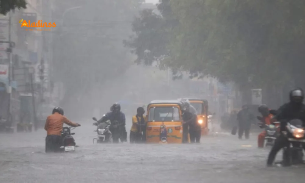
The India Meteorological Department (IMD) has predicted the formation of a low-pressure area over the northern Bay of Bengal, which is likely to influence weather patterns across Tamil Nadu and neighboring regions. This system, driven by variations in westerly wind speeds, is expected to bring light to moderate rainfall to northern and southern districts of Tamil Nadu, as well as Puducherry and Karaikal. The RMC’s bulletin indicates that the low-pressure area may persist for the next five days, potentially intensifying monsoon activity in the region. While widespread heavy rainfall is not anticipated, isolated showers with thunderstorms could lead to localized disruptions, particularly in low-lying areas prone to waterlogging.
The formation of low-pressure systems in the Bay of Bengal is a common occurrence during the monsoon season, often leading to increased rainfall along India’s eastern coast. The current system is expected to remain active until September 7, with meteorologists closely monitoring its development for any signs of intensification into a depression or cyclone. Such systems can bring both relief to drought-affected areas and challenges such as flooding and transportation disruptions, especially in coastal and hilly regions of Tamil Nadu.
Weather Forecast for Chennai
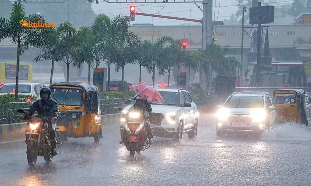
In Chennai and its suburbs, the RMC forecasts partly cloudy skies with light to moderate rain and thundershowers at a few locations. The maximum temperature in the city is expected to hover between 34°C and 35°C, while the minimum temperature will likely range from 26°C to 27°C. These conditions may lead to humid and warm weather, with occasional showers providing some relief. Residents are advised to prepare for potential disruptions due to rain, including traffic delays and minor waterlogging in low-lying areas of the city.
Chennai, a major metropolitan hub, is no stranger to monsoon-related challenges. Past instances of heavy rainfall have led to significant urban flooding, prompting local authorities to enhance drainage systems and preparedness measures. The current forecast, while not indicating severe rainfall, underscores the need for vigilance, particularly in areas with poor drainage infrastructure. The RMC’s updates will be critical for residents and businesses planning activities over the next five days.
Temperature Surge Across Tamil Nadu
The Meteorological Department has warned of a temperature increase of up to 3°C above normal across Tamil Nadu and Puducherry for the next five days. This rise could exacerbate discomfort, particularly in urban areas where the urban heat island effect amplifies temperatures. The combination of higher temperatures and intermittent rainfall may lead to humid conditions, posing challenges for outdoor workers, farmers, and residents. The RMC advises staying hydrated and avoiding prolonged exposure to heat during peak hours.
The temperature surge is attributed to the interplay of the low-pressure system and prevailing atmospheric conditions. While the rainfall may provide temporary relief, the overall warmer-than-normal conditions could strain power grids due to increased demand for cooling. Authorities are urging residents to conserve energy and prepare for potential power outages, especially in rural areas where infrastructure may be less resilient.
Fishermen Warning and Coastal Precautions
The RMC has issued a stern warning to fishermen, advising them to avoid venturing into the sea due to strong cyclonic winds. Wind speeds are expected to reach 45 to 55 kmph, with gusts up to 65 kmph, in the Midwest and Southwest Arabian Sea, as well as along the Konkan-Goa-Karnataka coasts, Lakshadweep-Maldives areas, and Southeast Arabian Sea. The southern Tamil Nadu coast, Gulf of Mannar, and Kumari Sea are particularly at risk, with squally conditions likely to prevail on September 2.
Additionally, the Andhra Pradesh, Odisha, and West Bengal coasts, along with most parts of the Bay of Bengal and the Andaman Sea, are expected to experience turbulent conditions. Fishermen have been instructed to refrain from sailing until the weather stabilizes, likely after September 7. The warning aims to prevent accidents at sea, as rough waves and strong winds pose significant risks to small fishing vessels. Coastal communities are also advised to secure boats and fishing equipment to minimize damage.
Impact on Agriculture and Infrastructure
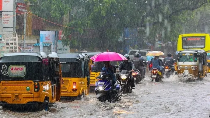
The anticipated rainfall, while moderate, could have mixed effects on Tamil Nadu’s agricultural sector. The state’s farmers, particularly those cultivating paddy and other rain-dependent crops, may benefit from the showers, which could replenish water sources in parched regions. However, excessive rainfall in low-lying areas could lead to waterlogging, potentially damaging crops and delaying harvests. Districts like Coimbatore and Nilgiris, which have previously experienced isolated heavy rainfall, are particularly vulnerable to such issues.
Infrastructure in urban centers like Chennai, Madurai, and Tiruchirappalli faces challenges during monsoon seasons, with drainage systems often struggling to cope with sudden downpours. The RMC’s alert has prompted local administrations to prepare for potential disruptions, including clearing drainage channels and deploying emergency response teams. The state government has also urged residents in hilly and coastal regions to remain vigilant and follow safety advisories to avoid risks associated with landslides or flooding.
Preparedness and Public Safety Measures
The Tamil Nadu government and local authorities are taking proactive steps to mitigate the impact of the forecasted weather. Disaster management teams have been placed on standby, particularly in districts prone to flooding, such as Chennai, Cuddalore, and Nagapattinam. The state’s experience with past cyclones and heavy rainfall events, such as Cyclone Michaung in December 2023, has led to improved preparedness, including the deployment of National Disaster Response Force (NDRF) and State Disaster Response Force (SDRF) teams in vulnerable areas.
Public advisories have been issued, urging residents to avoid unnecessary travel during heavy rain and to stay updated with RMC bulletins. Schools and colleges in some districts may face temporary closures if rainfall intensifies, and residents in low-lying areas are encouraged to relocate to safer locations if necessary. The government is also coordinating with coastal authorities to ensure compliance with the fishermen’s advisory, aiming to prevent loss of life at sea.
Regional Weather Context
The current low-pressure system is part of a broader weather pattern affecting India’s eastern and southern coasts. Similar systems have formed in the Bay of Bengal in recent weeks, bringing heavy rainfall to states like Andhra Pradesh, Odisha, and West Bengal. The IMD’s forecast aligns with earlier predictions of two low-pressure systems forming in September 2025, with the first expected to intensify near the West Bengal-Odisha coast by September 5. Tamil Nadu’s weather is influenced by these systems, as well as an upper-air cyclonic circulation over South India, contributing to the expected rainfall and temperature fluctuations.
The southwest monsoon, which remains active across Tamil Nadu, is likely to intensify with the formation of the low-pressure area, providing much-needed rainfall but also raising concerns about potential flooding in vulnerable areas. The IMD’s continuous monitoring ensures that any escalation in weather conditions will be communicated promptly, allowing authorities and residents to prepare accordingly.
Comment / Reply From
No comments yet. Be the first to comment!